It has been a minute, actually a lot of minutes. I have not captured any light from far away things since the end of April. The Suffolk VA skies have just been pretty terrible this summer… not to say there have not been any clear nights, they have just been very few and far between. Hopefully as the weather starts to cool down a bit I’ll get the opportunity to look up again. I have been doing a little maintenance (upgrades, backups, etc) on my All Sky Camera here recently. The camera is a bit out of focus, but I need a clear night to fix that… While I was doing the maintenance I documented my configuration of the overlay that is found on my All Sky Camera images and am sharing that in this post.
The Indi-AllSky platform allows you to configure overlay labels on the All Sky Camera image to display useful and interesting information about the image and the sky it was taken from.
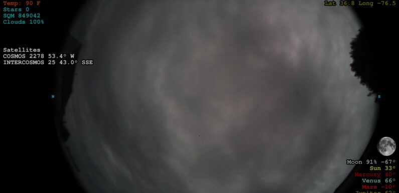
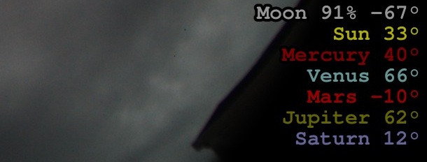
Below is a snapshot from my All Sky Camera with the overlay data.
Yep… 100% clouds. 🙁
Some of the available variables which can be used in the Label Template are:
timestamp, ts, day_date, exposure, rational_exp, gain, temp, temp_unit, sidereal_time, sqm, stars, detections, stack_method, stack_count, stretch, location, owner, latitude, longitude, kpindex, ovation_max, sun_alt, moon_alt, moon_phase, sun_moon_sep, moon_up, sun_moon_sep, mercury_alt, mercury_up, venus_alt, venus_up, venus_phase, mars_alt, mars_up, jupiter_alt, jupiter_up, saturn_alt, saturn_up, iss_alt, iss_up, iss_next_h, iss_next_alt, hst_alt, hst_up, hst_next_h, hst_next_alt, tiangong_alt, tiangong_up, tiangong_next_h, tiangong_next_alt
New variables are occasionally added. The indi-allsky Image Labels Wiki provides more details on the current label variables and how to use them to create a custom overlay for the All Sky images.
I am going to walk-through each section (upper right, lower right, lower left, and upper left) of my Label Template found in Indi-AllSky -> Overlays.
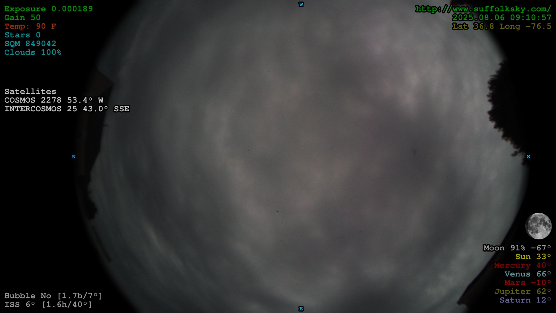
Upper Right All Sky Image Overlay
# size:30 [Use 60 for higher resolution cameras]
# xy:-15,15 (Upper Right)
# anchor:ra (Right Justified)
# color:0,150,0
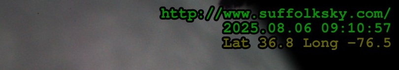
{location}
{timestamp:%Y.%m.%d %H:%M:%S}
# color:100,100,0
Lat {latitude:0.1f} Long {longitude:0.1f}
This displays the location and current time in the upper right hand corner of the image. The location, latitude, and longitude information is configured in Indi-AllSky -> Config -> Location
Lower Right All Sky Image Overlay
# xy:-15,-240 (Lower Right) [Use -15,-450 for size 60]
# color:150,150,150
Moon {moon_phase:0.0f}% {moon_alt:0.0f}°
# color:175,175,0
Sun {sun_alt:0.0f}°
# color:125,0,0
Mercury {mercury_alt:0.0f}°
# color:100,150,150
Venus {venus_alt:0.0f}°
# color:150,0,0
Mars {mars_alt:0.0f}°
# color:100,100,0
Jupiter {jupiter_alt:0.0f}°
# color:100,100,150
Saturn {saturn_alt:0.0f}°
Information about the Moon and Planets is displayed in the lower right corner of the image. The altitude is displayed for all the solar system objects, a negative number means the object is below the horizon. For the Moon the current phase (% Full) is also displayed.
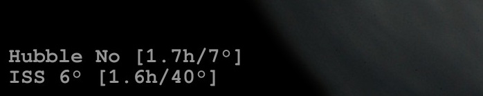
Lower Left All Sky Image Overlay
# xy:15,-75 (Lower Left) [Use 15,-210 for size 60]
# anchor:la (Left Justified)
# color:150,150,150
Hubble {hst_up:s} [{hst_next_h:0.1f}h/{hst_next_alt:0.0f}°]
ISS {iss_up:s} [{iss_next_h:0.1f}h/{iss_next_alt:0.0f}°]
Here is just some information about the visibility (is it up or not), next visibility, and the altitude of the Hubble Space Telescope and the International Space Station (ISS). I am thinking about removing this information and moving the Satellite Tracking overlay to this location.
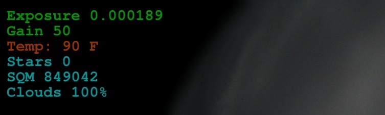
Upper Left All Sky Image Overlay
# xy:15,15 (Upper Left)
# color:0,150,0
Exposure {exposure:0.6f}
Gain {gain:d}
# color:150,50,0
Temp: {sensor_user_10:0.0f} {temp_unit:s}
# color:0,150,150
Stars {stars:d}
SQM {sqm:0.0f}
Clouds {sensor_user_23:0.0f}%
# color:200,200,200 (default color)
# additional labels will be added here
In the upper left of the image is the camera and environmental information. The exposure and gain of the current image along with the temperature. The temperature is from the DHT11 sensor configured as Sensor A at Indi-AllSky -> Config -> Sensors. The number of stars found in the image and the calculated SQM is displayed. The Clouds information is from the OpenWeather API Sensor configured as Sensor B at Indi-AllSky -> Config -> Sensors.
Moon Image Overlay and Satellite Tracking Overlay are not part of the overlay Label template. These are each enabled and configured in different parts of the indi-allsky config.
Moon Image Overlay
The Moon Image Overlay display an image of the current Moon phase on the image. This is enabled on the Overlays configuration Indi-AllSky -> Overlays. Enable the overlay and the X and Y position where it should be displayed. My X is configured for -100 and the Y is configured for -350. I have the overlay scale set to .25, so 1/4 of the 400×400 Moon image size.
Satellite Tracking Overlay
Indi-AllSky tracks around 100 or so bright satellites… information about satellites currently visible in the sky above can be overlayed on the All Sky image. This overlay is enabled and configured in Indi-AllSky -> Config -> Satellite Tracking. It displays information about satellites which “may” be in the current image FOV. More information on Satellite Tracking can be found in the indi-allsky Wiki.
# xy:15,300 (Left)
# anchor:la (Left Justified)
# color:200,200,200
Satellites
The Satellite Label Template configures what information is shown about visible satellites.
{title:s} {alt:0.1f}° {dir:s}
Available label variables can be found on the indi-allsky Satellite Tracking Wiki.
Full Overlay Label Template
Put it all together and the full image label configured in Indi-AllSky -> Overlays -> Label Template
# size:30 [Use 60 for higher resolution cameras]
# xy:-15,15 (Upper Right)
# anchor:ra (Right Justified)
# color:0,150,0
{location}
{timestamp:%Y.%m.%d %H:%M:%S}
# color:100,100,0
Lat {latitude:0.1f} Long {longitude:0.1f}
# xy:-15,-240 (Lower Right) [Use -15,-450 for size 60]
# color:150,150,150
Moon {moon_phase:0.0f}% {moon_alt:0.0f}°
# color:175,175,0
Sun {sun_alt:0.0f}°
# color:125,0,0
Mercury {mercury_alt:0.0f}°
# color:100,150,150
Venus {venus_alt:0.0f}°
# color:150,0,0
Mars {mars_alt:0.0f}°
# color:100,100,0
Jupiter {jupiter_alt:0.0f}°
# color:100,100,150
Saturn {saturn_alt:0.0f}°
# xy:15,-75 (Lower Left) [Use 15,-210 for size 60]
# anchor:la (Left Justified)
# color:150,150,150
Hubble {hst_up:s} [{hst_next_h:0.1f}h/{hst_next_alt:0.0f}°]
ISS {iss_up:s} [{iss_next_h:0.1f}h/{iss_next_alt:0.0f}°]
# xy:15,15 (Upper Left)
# color:0,150,0
Exposure {exposure:0.6f}
Gain {gain:d}
# color:150,50,0
Temp: {sensor_user_10:0.0f} {temp_unit:s}
# color:0,150,150
Stars {stars:d}
SQM {sqm:0.0f}
Clouds {sensor_user_23:0.0f}%
# color:200,200,200 (default color)
# additional labels will be added here
I hope you found this information helpful. If you are running an all sky camera I would love to hear from you, drop a note in the comments. If your camera is remotely web accessible be sure to include the link.
My camera can be accessed on the All Sky Camera page or live at https://vhersey.hopto.org:5010/indi-allsky/
I will try to get better focus once we have a clear night (if we ever have a clear night again).
Hopeful for clear skies soon…
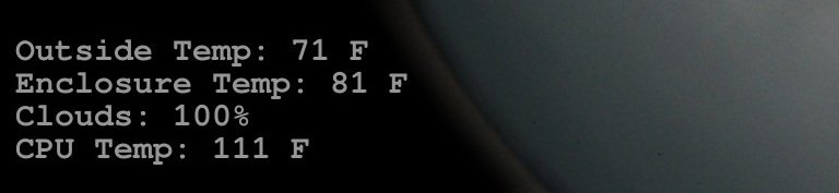
Quick Update – Lower Left Image Overlay
I made a change to the lower left, removing the ISS and HST data and moving the environmental information down there.
# xy:15,-150 (Lower Left) [Use 15,-210 for size 60]
# anchor:la (Left Justified)
# color:150,150,150
Outside Temp: {sensor_user_19:0.0f} {temp_unit:s}
Enclosure Temp: {sensor_user_10:0.0f} {temp_unit:s}
Clouds: {sensor_user_23:0.0f}%
CPU Temp: {sensor_temp_10:0.0f} {temp_unit:s}
The Outside Temp (sensor_user_19) and Clouds (sensor_user_23) are retrieved from the OpenWeather API configured as Sensor B and the Enclosure Temp is from the DHT11 attached to the Raspberry Pi inside the All Sky Camera enclosure configured as Sensor A.